Our system will evaluate the answer based on this AI-generated description.
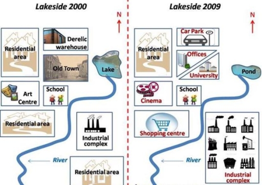
The image shows two side-by-side maps labeled "Lakeside 2000" and "Lakeside 2009" with a compass indicating North at the top of each map. In "Lakeside 2000," the map features a lake with an "Old Town" to its left, a "Derelict warehouse" above the lake, a "Residential area" to the right of the lake and above the "Old Town," an "Art Centre" below the "Old Town," a "School" below the "Art Centre," a "Residential area" below the "School," an "Industrial complex" to the right of the "Residential area" and below the lake, and another "Residential area" below the "Industrial complex," all areas separated by a wavy "River" running from the bottom left to top right of the map. In "Lakeside 2009," the same wavy "River" runs through the map, the previous "Lake" is now a "Pond," the "Old Town" and "Derelict warehouse" have been replaced by "University" and "Offices" respectively, the "Residential area" to the right of the "Pond" remains, the "School" is in the same position but now has a "Cinema" above it, the "Art Centre" has been replaced by a "Shopping centre," the "Residential area" below the "School" remains, the "Industrial complex" remains in the same position, and the "Residential area" below the "Industrial complex" also remains.
Given the complexity of the image, the above description may not be entirely accurate.
Skyrocket your IELTS band score by 1-2 points in under a month with our premium plan!
Note: Both the topic and the answer were created by one of our users.
The images illustrate the layout of the town/city called Lakeside from 2000 to 2009/ over a span of 9 years(2000-2009).
From an overall perspective, the city was transformed from an underdeveloped industrial estate into developed one. It is also apparent that although the area experienced major changes with respect to its amenities, some features were not subject to change.
Looking at the outline of Lakeside in 2000, an art center was situated in the west, flanked by two residential areas – one in its north and the other one in its south. While a derelic warehouse could be found in the north, old town was to the south of it. A school was located in the heart/center of the city. Additionally, there was a river running from south to east, with a lake on its northern mouth. In the south-east, an industrial complex was located, with a residential area being on its south.
After a nine-year period, the town underwent a complete makeover. While the art center was repurposed into a cinema, the residential area in its south was demolished to make way for a shopping center. A new parking lot was erected at the expanse of the old warehouse. The old town was knocked down to build offices and a university. Although the southern residential area was erased to expand the industrial complex, the northern residential area and the school remained unaltered/unchanged. Finally, the lake shrank significantly, turning into a pond.
Word Count: 242
