Our system will evaluate the answer based on this AI-generated description.
The image depicts two maps illustrating the changes in the town of Harton from 2008 to 2016. In 2008, key features include separate residential areas in the northeast and southwest, a derelict warehouse, Old Town, arts center, and woodland to the west, a residential area in the center, and an industrial complex in the southeast. By 2016, notable transformations include the replacement of the derelict warehouse with a multi-screen cinema, the installation of a university and offices where Old Town once was, the creation of a car park, and shopping center near the previous central residential area, the transformation of the central residential area into a multi-screen cinema, and a change from lake to pond next to the woodland. Additionally, industrial complex has expanded, and a more defined separation of the residential areas is evident. The river remains consistent in shape and position in both maps.
Given the complexity of the image, the above description may not be entirely accurate.
Skyrocket your IELTS band score by 1-2 points in under a month with our premium plan!
Note: Both the topic and the answer were created by one of our users.
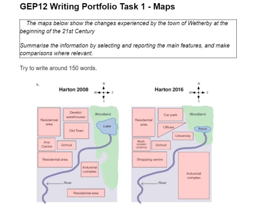
The maps illustrate the developments that took place in the Harton town over the period of eight years from 2008 to 2016. Overall, it can be seen that the area in the eastern part of the river became industrialized, and the zone in the western turned into urbanized.
The neighborhood, on the western river, experienced a significant change during the period provided. For instance, the derelict warehouses to the west of the woodland gave way to the car park, and old Town to the east of the residential area was replaced by the offices. Moreover, the Arts Center west of the school was built in place of the Multi-screen cinema while the residential area south of the school was reconstructed to become the shopping center. However, the residential area to the
north of the Arts Center and the school to the south of the Old Town remained the same.
By 2016, there was even greater transformation in the eastern side of the river. The industrial complex was extended, replacing the residential area that was located southeast of the map. Furthermore, the woodland in the northwest was reduced in size, and the lake to the east of the old town was given over to the pond with minimize the width.
Word Count: 209