24 Hours Only: Get 39% OFF on Our Premium Plan - Check Out Now!
Map

Band 5+: The maps below show the development of the village of Ryehath between 1990 and 2015 Summarize the information by selecting and reporting the main features and make comparisons where relevant.

Image for topic: The maps below show the development of the village of Ryehath between 1990 and 2015 Summarize the information by selecting and reporting the main features and make comparisons where relevant.
Our system will evaluate the answer based on this AI-generated description.
The image contains two maps, one labeled 1990 and the other 2015, illustrating changes in a town over this period. In 1990, from north to south, there is a forest with three icons for trees, a river, an Aberay road with a bus station on one side and a car on the other, a main road with two cars, another river, and another forest with four icons for trees. On the east side of the Aberay road, there are two trees, a footpath with three people icons, a farmland with two hay icons, an empty plot, a shop, and a school. On the west side, there is a forest, another footpath with two people icons, two gardens, and six houses. In 2015, from north to south, there is a cafe with two fork and spoon icons, a river, a bridge, an Aberay road with a bus station and car park marked with "P", a main road with two cars, another river, and a housing area with nine house icons. On the east side of the Aberay road, there are three trees, a footpath with four people icons, a pasture with one cow icon, and three additional shops. On the west side, there is a park with two tree icons, another footpath with three people icons, a primary school with one book icon, a college with one diploma icon, and a garden.
Given the complexity of the image, the above description may not be entirely accurate.
Note: Both the topic and the answer were created by one of our users.

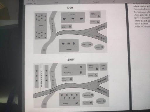
The two maps illustrates how the village of Ryehath , situated by banks of the river, changed over a period from 1990 to 2015. The disappearence of forest and farmland are the major changes during this period.

Overall, there is a considerable development of the settlement over these years and gradually transformed from a rural village into a largely resedential area and commercial area. The primary school, garden and police station has remained unchanged over the period.

The most notable changes would be the replacement of forests that lies west side of the river, with the residences of the people. The farmland which is situated on northern and southern part of the village parted by the road now replaced by a cafe, gas sation in the north and houses with parking space in the south.

There is a cliff road constructed in north-east side of the map connected to the bridge constructed across the river. The college has been constructed to the east side of primary school and the shops are replaced by the supermarket and post office in the south-east part of the village.

Word Count: 185

Answers On The Same Topic:

The maps below show the development of the village of Ryehath between 1990 and 2015 Summarize the information by selecting and reporting the main features and make comparisons where relevant.

The two map illustrates the development and changes that took place in the village of Ryehath between 1990 and 2015. Overall, the Ryehath village undergone significant transformation in 2015.Although the key landmarks like primary school, garden, windmill and police station are left unchanged. To begin with, one notable change that a bridge was built over […]

The maps below show the development of the village of Ryehath between 1990 and 2015 Summarize the information by selecting and reporting the main features and make comparisons where relevant.

The two maps illustrate the changes in the town of Ryehath between 1990 and 2015. Overall, the area underwent significant transformation over the 25 year period with several residential developments, replacing natural and public spaces. The village became more urbanised and modernized In 1990, the area to the West of the river featured a thick […]

The maps below show the development of the village of Ryehath between 1990 and 2015 Summarize the information by selecting and reporting the main features and make comparisons where relevant.

The two maps illustrates the changes and development that took place in Ryehath village between 1990 and 2015. Overall Ryehath village underwent significant transformations by 2015, although key landmarks such as the primary school, police station, windmill, and garden remained unchanged. To begin with, one notable change was the construction of a bridge over the […]

The maps below show the development of the village of Ryehath between 1990 and 2015 Summarize the information by selecting and reporting the main features and make comparisons where relevant.

These two maps depict the modifications and variations that occurred in Ryehath village from 1990 to 2015. Overall, there were spectacular alterations in this village in 2015. However, the primary school, police station, windmill, and garden were still in the same place. To begin with, one interesting change was that abridge has been constructed over […]

The maps below show the development of the village of Ryehath between 1990 and 2015 Summarize the information by selecting and reporting the main features and make comparisons where relevant.

The given maps show the development of a village called Ryehath between 1990 and 2015 a period of 25 years. There are many changes that took place during this time. Firstly, the forest that was available to the west side of the village was completely destroyed and is utilized to build houses. Adding to that […]

See All

Other Topics:

The map below shows the plan of a proposed new town. Summarise the information by selecting and reporting the main features, and make comparisons where relevant. You should write at least 150 words.

The map illustrates the plan of an anticipated new town. Overall, this map reveals a residential area, there will be a lot of houses in both the center and outskirts area. Ring roads will divide this town into two main areas. In the center area, there are four roads to go to this area. Houses […]

The map below shows a school in 1985 and the school now. Summarize the information by selecting and reporting the main features, and make comparisons where relevant.

The maps give information about how a school has changed since 1985. Overall, it has witnessed major rearrangements, with the introduction of several modern facilities and new classroom blocks in order to accommodate the growth in the school population. Looking first at the bottom of the school, the spacious playing field at the bottom has […]

You should spend about 20 minutes on this task. The maps below show the centre of a small town called Islip as it is now, and plans for its development. Summarise the information by selecting and reporting the main features, and make comparisons where relevant. Write at least 150 words.

The first picture shows the layout of Islip town centre, and the second shows some proposed changes to the town space. Overall, it is clear that the road will be expanded. Moreover, facilities will be located inside the road and new ones will be constructed. Also, some new housings will be located in this area. […]

The plans below show a bookstore in 2000 and the bookstore now. Summarise the information by selecting and reporting the main features, and make comparison where relevant.

The illustration shows the previous bookstore back in 2000 and the present bookstore. It also indicates the significant changes between the past and current bookstore. Overall, there are major differences in the current bookstore such as the cafe counter with table acommodations. In addition, the huge allocated shelve for fiction in the previous bookstore became […]

The two maps show changes to the Riverside University campus between 2005 and 2025. Summarise the information by selecting and reporting the main features, and make comparisons where relevant.

The picture represents some modifications of the Riverside University campus over twenty years from 2005 to 2025. Overall, the campus for students is located at the south bank of a river along the main road. As illustrated in the picture in 2005 the university site concluded a the universities library, the main building, and a […]

Chorleywood is a village near London whose population has increased steadily since the middle of the nineteenth century. The map below shows the development of the village

Themap illustrates developed erection of Chorleywood village where located near to the London and from the mid 19th century its population keep growing. Overall, it can be seen from the map that contain four periods (1868-1883, 1883-1922, 1922-1970, 1970-1994) and three type of constructions, including main road, motorway and railway. At the beginning of the […]

See All
We have detected unusual activity on your device.
Please verify your identity to continue.
Note: This verification step won't sign you in. If you have a premium account, please log in to access the service as usual.
Google/Gmail Verification
Or verify using Email/Code
We've sent a verification code to:
youremail@gmail.com (Not your email?)
Enter it below to complete the verification process.
Ensure your email address is correct, your inbox is not full, and you check your spam folder. If no email arrives, consider using an alternative email.
You will need a Premium plan to perform your action!
Note: If you already have a premium account, please log in to access our services as usual.

Plans & Pricing

Our mission is to make quality education accessible and free for everyone.
However, to keep our hardworking team running and this service alive, we genuinely need your support!
By opting for a premium plan, not only do you sustain us in achieving the mission, but you also unlock advanced features to enrich your learning experience.

Free

For learners who aren't pressed for time

What's included on Free
1000+ IELTS Tests & Samples
Instant IELTS Writing Task 1 & 2 Evaluation (2 times/month)
Instant IELTS Speaking Part 1, 2, & 3 Evaluation (5 times/month)
Instant IELTS Writing Task 1 & 2 Essay Generator (2 times/month)
500+ Dictation & Shadowing Exercises
100+ Pronunciation Exercises
Flashcards
Other Advanced Tools

Premium

For those serious about advancing their English proficiency, and for IELTS candidates aspiring to boost their band score by 1-2 points (especially in writing & speaking) in just 30 days or less

What's included on Premium
Save Your IELTS Test Progress
Unlock All Courses & Content
Unlimited AI Conversations
Unlimited AI Writing Enhancement Exercises
Unlimited IELTS Writing Task 1 & 2 Evaluation
Unlimited IELTS Speaking Part 1, 2, & 3 Evaluation
Checked Answers Will Not Be Published
Unlimited IELTS Writing Task 1 & 2 Essay Generator
Unlimited IELTS Speaking Part 1, 2, & 3 Sample Generator
Unlimited Usage Of Advanced Tools

Due to the nature of our service and the provided free trials, payments are non-refundable.
Nếu bạn là người Việt Nam và không có hoặc không muốn trả bằng credit/debit cards, bạn có thể thanh toán bằng phương thức chuyển khoản:


Chọn gói:
279,000₫ 157,000 ₫ cho gói 1 tháng (chỉ 5,233₫/ngày)
819,000₫ 397,000 ₫ cho gói 3 tháng (chỉ 4,411₫/ngày)
1,649,000₫ 667,000 ₫ cho gói 6 tháng (chỉ 3,706₫/ngày)
3,299,000₫ 857,000 ₫ cho gói 12 tháng (chỉ 2,381₫/ngày)


Sau khi chuyển khoản, vui lòng đợi trình duyệt tự động điều hướng bạn trở lại Engnovate và bạn sẽ ngay lập tức nhận được mã kích hoạt tài khoản premium.
Nếu có lỗi xảy ra, bạn có thể liên hệ với team thông qua một trong các phương thức: email đến helloengnovate@gmail.com hoặc nhắn tin qua facebook.com/engnovate.
Vì toàn bộ công cụ trên website đều có thể sử dụng thử miễn phí, Engnovate không hỗ trợ hoàn tiền.