Our system will evaluate the answer based on this AI-generated description.
The image contains two maps, one labeled 1990 and the other 2015, illustrating changes in a town over this period. In 1990, from north to south, there is a forest with three icons for trees, a river, an Aberay road with a bus station on one side and a car on the other, a main road with two cars, another river, and another forest with four icons for trees. On the east side of the Aberay road, there are two trees, a footpath with three people icons, a farmland with two hay icons, an empty plot, a shop, and a school. On the west side, there is a forest, another footpath with two people icons, two gardens, and six houses. In 2015, from north to south, there is a cafe with two fork and spoon icons, a river, a bridge, an Aberay road with a bus station and car park marked with "P", a main road with two cars, another river, and a housing area with nine house icons. On the east side of the Aberay road, there are three trees, a footpath with four people icons, a pasture with one cow icon, and three additional shops. On the west side, there is a park with two tree icons, another footpath with three people icons, a primary school with one book icon, a college with one diploma icon, and a garden.
Given the complexity of the image, the above description may not be entirely accurate.
Skyrocket your IELTS band score by 1-2 points in under a month with our premium plan!
Note: Both the topic and the answer were created by one of our users.
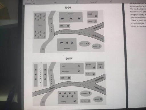
The given maps depict the development of the village of Ryehath between 1990 and 2015. Many adjustments and replacements have been made to modify the village over 25 years.
Firstly, the farmland has been eliminated from the rural area, replaced with a cafe and petrol pump on one side of the main road. On the other hand, the farmland near Abbey Road has been replaced with houses with a parking area. Even though the river remained the same; the bridge presented to cross the waters was demolished to its one-fourth part.
Furthermore, the forest was cut down to build houses which were separated by a Cliff road. The shops that were present in 1990 were turned into supermarkets by the year 2015. However, in 2015, a post office has been established near the market. A college has been constructed beside the primary school.
Particularly, talking about the few where changes have not taken place: the Police station, the Garden, and the Windmill remained the same through all the years. The Abbey Road and the Main Road were connected the same; they were in 1995.
Word Count: 184