Our system will evaluate the answer based on this AI-generated description.
The image showcases a comparative layout of Liverton in two different time frames, 1980 and the present, with structural changes indicated by a key for replacements and newly built areas. In 1980, Liverton comprises two waewhouses flanked by two cranes on the riverside above four ships arranged horizontally, with an additional crane and waewhouse further downstream, signifying an industrial riverfront environment leading to the coast. In the current depiction, transformed areas feature an education centre, sailing club, kid's playground, and a flood barrier replacing previous infrastructures, alongside a newly constructed bridge over the river. Below this lies a ship museum adjacent to a hotel, river walk, newly built apartments, and parking facilities, showcasing updated functionalities with arrows illustrating directionality toward the coast.
Given the complexity of the image, the above description may not be entirely accurate.
Skyrocket your IELTS band score by 1-2 points in under a month with our premium plan!
Note: Both the topic and the answer were created by one of our users.
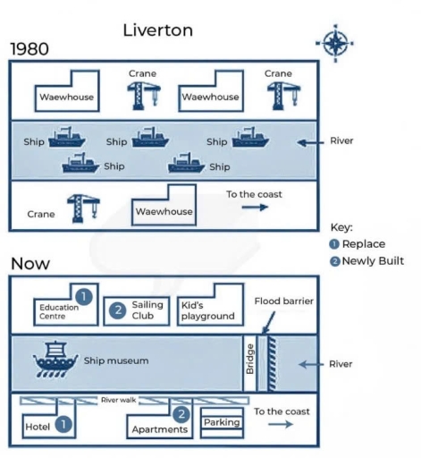
The maps illustrate changes that took place in Liverton Docks since 1980.
Overall, the area has undergone a significant transformation, with ships replaced by a ship museum and the addition of both commercial and educational infrastructures.
In 1980, Liverton Docks used to be an industrial zone. A river flowed in the middle of the map, and it was filled with many ships directed towards the east to the coast. Along the northern part of the river, there were 2 warehouses and 2 cranes. Meanwhile, the southern part also had a warehouse and a crane standing on the left.
However, following a complete makeover, the area has transformed into a residential area with both educational and commercial services. Ships were removed in the middle, and a ship museum has been constructed instead. On the eastern part, a bridge has been built with a flood barrier, which prevents flooding. On the upper part of the map, warehouses have been replaced by an education centre and a kid’s playground, and also, there is a newly built sailing club between them. As for the southern side, a hotel, apartments, and a parking area have been introduced, all of which are connected by a river walk.
Word Count: 201