Our system will evaluate the answer based on this AI-generated description.
The image presents two maps of Porth Harbour; the 2000 map shows a seawall on the west, a cranes area to the north of the seawall, and a warehouse positioned east of the cranes. East of the warehouse is a café; north of the café is a fishing area; northeast of the café is a boat yard; southeast is a dockyard; directly east is a fishing area; and south is a car park area with a main road extending from north to south connecting all main structures, leading to a lighthouse to the northeast of the car park. The current map introduces sailing clubs replacing the cranes and boat yard, the former warehouse converted to apartments, the fishing area near the apartments also replaced with another sailing club. The café and east fishing area remain unchanged, but to the north of the road (and east of the main road) new establishments (cafés, shops) are present along with a new footpath extending from the main road to the lighthouse.
Given the complexity of the image, the above description may not be entirely accurate.
Skyrocket your IELTS band score by 1-2 points in under a month with our premium plan!
Note: Both the topic and the answer were created by one of our users.
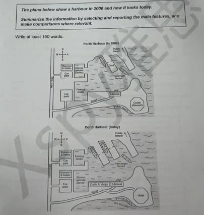
The given map details Porth Harbor in the past and alterations made in the present day. Looking from an overall perspective, it is readily apparent that the harbor has become more accessible through additional docking options, and transitioned generally from being used for commercial fishing and some private boating to a mostly recreational waterfront area.
In the past, there was a single dock in the norther section of the harbor, just below a public beach stretching further northwards. At present, the beach remains the same but another dock serving passenger ferries has been added. Slightly south and west of the docks, there was previously a marina for private yachts, showers and toilets and a car park connected to the main road running north to south. The only change today is the marina has now been relocated to the immediate south.
In the southwestern section of the harbor, the marina (which replaced an open harbor for fishing boats) is adjacent to new showers and toilets and a pre-existing second car park linked to the main road. On the eastern peninsula, the existing lifeboat and private beach are now accompanied by cafes and shops and a smaller road leading to a new hotel to the furthest eastern point.
Word Count: 206