Our system will evaluate the answer based on this AI-generated description.
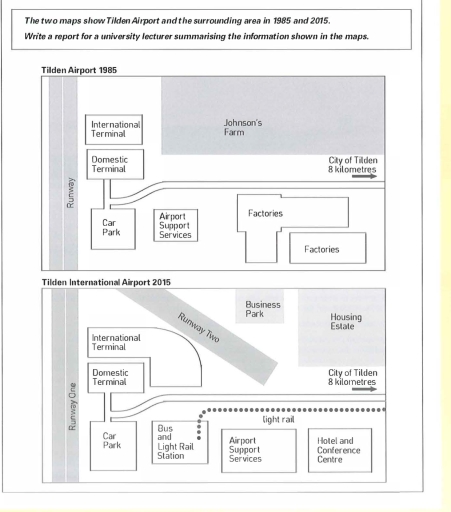
The image consists of two distinct maps depicting Tilden Airport and its surroundings in 1985 and 2015, showing infrastructure and layout changes over the 30-year interval; in 1985, the airport features an international terminal positioned to the north of a domestic terminal adjacent to Runway One, which had surrounding facilities comprising a car park, airport support services, and two factory areas to the southeast, while Johnson's Farm is situated north of the international terminal, and the city of Tilden is consistently labeled 8 kilometers east; in 2015, Tilden Airport is renamed Tilden International Airport, and Runway One is joined by an additional Runway Two intersecting existing facilities, with enhanced infrastructure including a bus and light rail station near parking areas, airport support services relocated southeast accompanied by a hotel and conference center, the former farm replaced by a business park north of Runway Two, and a new housing estate replacing factories beside the business park; consistent distance to the city of Tilden remains unchanged across both maps at 8 kilometers east.
Given the complexity of the image, the above description may not be entirely accurate.
Skyrocket your IELTS band score by 1-2 points in under a month with our premium plan!
Note: Both the topic and the answer were created by one of our users.
The two provided maps illustrate changes in Tilden Airport and the surrounding area in the period of time between 1985 and 2015.
Overall, the area underwent significant modifications, beginning with the addition of new facilities that replaced the old ones, such as factories and Johnson’s farm, and finishing with the extention of the existing structures.
Focusing on the South of the maps, it is clear that the region changed significantly; there, the factories was converted into two new different accomodations, namely the hotel and conference centre on right, and the airport support services that before was located in the adjacent structure on its left, whereas now, there is the bus and light rail station, including the railway.
The West side of the map has remained unchanged, with the exception of the international terminal that was expandend, reaching twice the size of the past. Finally, to the north of the whole site, Johnson’s farm was replaced by the housing estate, the business park, and another track called runway two.
Word Count: 168