🔥 Today Only: Save 30% on Premium — Offer Ends Soon! - Upgrade Now!
Map

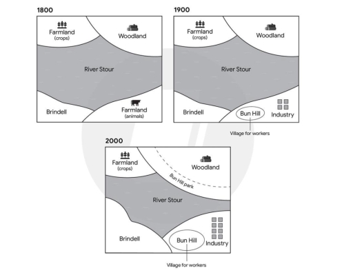
Band 6+: Task 1: The diagrams below show the development of a town called Brindell and the local areas in 1800, 1900 and 2000.Provide an overview of the information by identifying and describing the key details, and include comparisons where appropriate.

Image for topic: Task 1: The diagrams below show the development of a town called Brindell and the local areas in 1800, 1900 and 2000.Provide an overview of the information by identifying and describing the key details, and include comparisons where appropriate.
Our system will evaluate the answer based on this AI-generated description.
The image displays three maps illustrating the geographical layout evolution over three distinct periods: in 1800, the map includes River Stour centrally, Woodland at the top right corner, Farmland (crops) at the top left, Farmland (animals) towards the right of Brindell, and no villages or industry; in 1900, the map shows River Stour also centrally located, Woodland reduced at the top right, Farmland (crops) at the top left, Brindell remains at the bottom left, Bun Hill appears adjacent to the Industry symbol towards the bottom right along with a "Village for workers" label; by 2000, the map presents the River Stour amid the landscape, decreased Woodland at the top right with the addition of Bun Hill Park encircling a segment, relocated Farmland (crops) to top left, Brindell stays at the bottom left, Bun Hill relocated left of Industry which increased in area, an expansion in the built environment noted with a larger "Village for workers" denotation.
Given the complexity of the image, the above description may not be entirely accurate.
Note: Both the topic and the answer were created by one of our users.

The provided diagrams illustrate the development of Brindell town and the adjacent local areas in 3-century intervals which are 1800, 1900, and 2000.

Overall, the region demonstrated remarkable adjustments throughout the given period especially in the 21st century.

In detail, in 1800 the town consisted of two farmlands, the former is for cultivating and harvesting crops and the latter is for rearning and breeding animals. In addition, there was a woodland and River Stour was centering the area.

However, slight modifications took place in 1900 especially in animal farmland that was replaced with a tremendous industrial spot along with the construction of Bun Hill beside the factories , which is a village for the industry workers to stay close to the industry.

The prodigious change happened in 2000 , where Brindell town upsized and the number of factories increased. Morover, another Bun Hill was constructed in the woodland.

Word Count: 148

Answers On The Same Topic:

Task 1: The diagrams below show the development of a town called Brindell and the local areas in 1800, 1900 and 2000.Provide an overview of the information by identifying and describing the key details, and include comparisons where appropriate.

The layout illustrate the major developments in the Brindell town and surrounded area from 1800, 1900, and 2000. Overall,the Brindell town was developed significantly with many facilities and amenities over the period. Further,both woodland and industrial zone were expanded in 2000. Besides the river Stour shrink in 2000. In the map, the river is situated […]

Task 1: The diagrams below show the development of a town called Brindell and the local areas in 1800, 1900 and 2000.Provide an overview of the information by identifying and describing the key details, and include comparisons where appropriate.

Three maps illustrate significant changes in Brindell and other areas over 200 years from 1800. Overall, it is clear that while Wooland, Brindell expanded, river stour and crop famland underwent a moderate reduction. Futhermore, animal farmland was converted into industry area. The Brindell town and the woodland was remained from 1800 to 1900, but they […]

See All

Other Topics:

The maps show a town centre in 1990 and same town centre today.

The image details two town centre maps highlighting changes from 1990 to today From an overall perspective, it is readily apparent that the town center has become significantly more urbanized and modernized, featuring expanded accessibility and commerical amenities alongside enhanced residential sectors. These enhancements occurred at the expense of several vehicle roads, a variety of […]

The maps below show a coal mining site before and after redevelopment. Summarise the information by selecting and reporting the main features and make comparisons where relevant.

The maps illustrate the redevelopment of a coal mining site, showing its layout before and after the changes. Overall, the coal mining site has undergone significant changes towards tourism, with staff areas being converted into a museum. In addition, while the car park has remained unchanged, two waste tips have been removed completely to accommodate […]

The maps below show tourists a number of di#erent ways of visiting Mount Eron in a national park. Summarise the information by selecting and reporting the main features, and make comparisons where relevant.

The map illustrates a number of ways a number of ways that tourists can use to visit Mount Eron, which is located in a national park. Overall, the mountain is centrally located in the park surounded by driving tracks and a walking track. Furthermore, there are two main ways into the park. In the northwest, […]

The diagrams below show the present building of a college and the plan for changes to the college site in the future.

The maps illustrate some changes that were made to the current building of a college and the future plan of the college site in 2020. It is clear that, a number of major modification were made to the plan for changes to the college site in the future. These include removing the garden and footpath, […]

The two maps illustrate the vehicular connections to a city hospital over a span of 3 years, in 2007 and 2010.

The maps shows the changes that happened around a city hospital within three years. Overall,the changes included adding rondabouts and more parking lots in the south and the east side of the hospital. In 2007, the entry to the building was direct from the city road with only a one single road that leads you […]

The map below sow the changes in area after the construction of a hydroelectric power dam.

The map compares the layout of the construction of hydroelectric power dam as it was in 1980 with its renewed design in 2000. Overall, this area had undergone several modifications. In 1980,the area primarily focused on agricultural facilities and biodiversity, after the redevelopments, this site became more leisure-oriented and hospitable services. The major change was […]

See All
We have detected unusual activity on your device.
Please verify your identity to continue.
Note: This verification step won't sign you in. If you have a premium account, please log in to access the service as usual.
Google/Gmail Verification
Or verify using Email/Code
We've sent a verification code to:
youremail@gmail.com (Not your email?)
Enter it below to complete the verification process.
Ensure your email address is correct, your inbox is not full, and you check your spam folder. If no email arrives, consider using an alternative email.
You will need a Premium plan to perform your action!
Note: If you already have a premium account, please log in to access our services as usual.

Plans & Pricing

Our mission is to make quality education accessible for everyone.
However, to keep our hardworking team running and this service alive, we genuinely need your support!
By opting for a premium plan, not only do you sustain us in achieving the mission, but you also unlock advanced features to enrich your learning experience.

Free

For learners who aren't pressed for time

What's included on Free
100+ Cambridge IELTS Tests
Instant IELTS Writing Task 1 & 2 Evaluation (2 times/month)
Instant IELTS Speaking Part 1, 2, & 3 Evaluation (5 times/month)
Instant IELTS Writing Task 1 & 2 Essay Generator (2 times/month)
500+ Dictation & Shadowing Exercises
100+ Pronunciation Exercises
Flashcards
Other Advanced Tools

Premium

For those serious about advancing their English proficiency, and for IELTS candidates aspiring to boost their band score by 1-2 points (especially in writing & speaking) in just 30 days or less

What's included on Premium
Save Your IELTS Test Progress
Unlock All Courses & IELTS Tests
Unlimited AI Conversations
Unlimited AI Writing Enhancement Exercises
Unlimited IELTS Writing Task 1 & 2 Evaluation
Unlimited IELTS Speaking Part 1, 2, & 3 Evaluation
Checked Answers Will Not Be Published
Unlimited IELTS Writing Task 1 & 2 Essay Generator
Unlimited IELTS Speaking Part 1, 2, & 3 Sample Generator
Unlimited Usage Of Advanced Tools
Priority Support within 24h (12-month plan only)

Due to the nature of our service and the provided free trials, payments are non-refundable.
Nếu bạn là người Việt Nam và không có hoặc không muốn trả bằng credit/debit cards, bạn có thể thanh toán bằng phương thức chuyển khoản:


Chọn gói:
419,000₫ 277,000 ₫ cho gói 1 tháng (chỉ 9,233₫/ngày)
1,239,000₫ 597,000 ₫ cho gói 3 tháng (chỉ 6,633₫/ngày)
2,469,000₫ 1,027,000 ₫ cho gói 6 tháng (chỉ 5,706₫/ngày)
4,929,000₫ 1,417,000 ₫ cho gói 12 tháng (chỉ 3,936₫/ngày)


Sau khi chuyển khoản, vui lòng đợi trình duyệt tự động điều hướng bạn trở lại Engnovate và bạn sẽ ngay lập tức nhận được mã kích hoạt tài khoản premium.
Nếu có lỗi xảy ra, bạn có thể liên hệ với team thông qua một trong các phương thức: email đến helloengnovate@gmail.com hoặc nhắn tin qua facebook.com/engnovate.
Vì toàn bộ công cụ trên website đều có thể sử dụng thử miễn phí, Engnovate không hỗ trợ hoàn tiền.