Our system will evaluate the answer based on this AI-generated description.
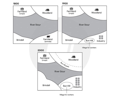
The image displays three maps illustrating the geographical layout evolution over three distinct periods: in 1800, the map includes River Stour centrally, Woodland at the top right corner, Farmland (crops) at the top left, Farmland (animals) towards the right of Brindell, and no villages or industry; in 1900, the map shows River Stour also centrally located, Woodland reduced at the top right, Farmland (crops) at the top left, Brindell remains at the bottom left, Bun Hill appears adjacent to the Industry symbol towards the bottom right along with a "Village for workers" label; by 2000, the map presents the River Stour amid the landscape, decreased Woodland at the top right with the addition of Bun Hill Park encircling a segment, relocated Farmland (crops) to top left, Brindell stays at the bottom left, Bun Hill relocated left of Industry which increased in area, an expansion in the built environment noted with a larger "Village for workers" denotation.
Given the complexity of the image, the above description may not be entirely accurate.
Skyrocket your IELTS band score by 1-2 points in under a month with our premium plan!
Note: Both the topic and the answer were created by one of our users.
The layout illustrate the major developments in the Brindell town and surrounded area from 1800, 1900, and 2000.
Overall,the Brindell town was developed significantly with many facilities and amenities over the period. Further,both woodland and industrial zone were expanded in 2000. Besides the river Stour shrink in 2000.
In the map, the river is situated in the central of the map and it flows from West to East. The main attractions of farmland, Brindell, and woodland remained a same location throughout the period. But Brindell and woodland were expanded significant in 1900 further a new Bun Hill Park was included in 1900 and it bring more benefits to woodlant visitors. Moreover. Brindell area has been extended into two fold in 2000. However,initial farmland has been converted into a Bun hill and a industry in 1900, that had provided many facilities to village workers. In noticeable that industry zone has been doubled in 2000.
Word Count: 153
