Our system will evaluate the answer based on this AI-generated description.
The image contains two diagrams, labelled "NOW" and "PROPOSED PLAN," depicting two different layouts of an area with various features. In the "NOW" diagram, there is an Airfield in the top left corner connected to a Roundabout, which is linked to three roads - one towards the Gas station in the bottom left corner, one towards the Town center in the middle right, and one intersecting a Railway with a Bridge above the Railway, leading upwards with 'build-up area' written alongside. A fourth road encircles the Town center marked as 'ring-road'. In the "PROPOSED PLAN" diagram, the layout is slightly altered; the 'Industrial estate' now appears above the Railway in the upper right corner, connected to a modified 'ring-road' with 'build-up area' written along it again. The Gas station has moved towards the bottom right and is positioned on a new road labelled 'A4' extending outside of the diagram's boundary, marked with a dashed line. The Roundabout, Airfield, and Town center remain in similar positions, and 'A2' is written alongside the road between the Roundabout and Industrial estate.
Given the complexity of the image, the above description may not be entirely accurate.
Skyrocket your IELTS band score by 1-2 points in under a month with our premium plan!
Note: Both the topic and the answer were created by one of our users.
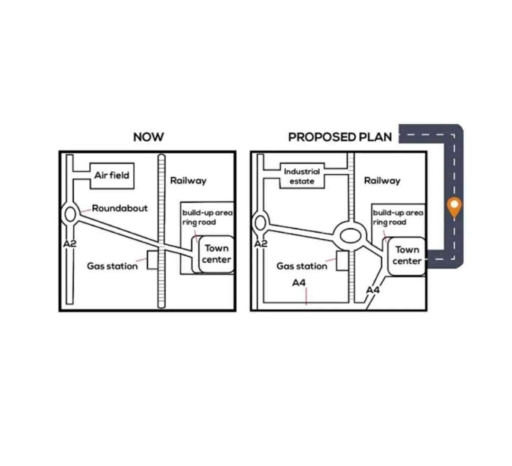
The map provides information about the contraction of the town presently and shifts which are planned for the future.
Overall, it is clear that the proposed plan has a number of differences to compare with the present plan of the town. For instance, the new highway and road or building of a new roundabout.
Looking at the present plan of the city, the map shows the little part of the town which consists of road A2 connecting with the airfield and has a roundabout which connects road A2 and the town center. Also, a railway crosses right here near the cross point where a gas station is located.
On the other hand, in the proposed plan, an industrial estate is located in the northwest corner of the map instead of the airfield. While between the roundabout of road A2 and the town center, a new roundabout is built. Also, a new road, namely A4, which crosses with A2, the railway, and the town center, is opened. Meanwhile, the gas station and ring road area stay at their locations. Indeed, a new highway is built after the town center.
Word Count: 188