Our system will evaluate the answer based on this AI-generated description.
The image depicts two illustrated maps labeled with the years 1990 and 2005, showing changes in a location's infrastructure over time. In the 1990 map, the layout includes a railway station at the extreme right, a hospital and a school situated near each other at the center, and a parking area on the left side. The structures are surrounded by a substantial number of trees and residential houses. A road runs horizontally through the center of the map with one bridge crossing over a body of water. The compass on the map indicates North is towards the upper left corner. In the 2005 map, several changes are noted, including the addition of a supermarket next to the hospital, a factory located on the lower side of the railway station, and a ferry terminal at the far right. The school maintains its position, but the parking area has been relocated to a spot between the supermarket and the hospital. The number of residential houses appears reduced, and the natural scenery has been diminished, with fewer trees shown. The central road appears wider with two bridge crossings, and the compass indicates North in the same direction as in the 1990 map.
Given the complexity of the image, the above description may not be entirely accurate.
Skyrocket your IELTS band score by 1-2 points in under a month with our premium plan!
Note: Both the topic and the answer were created by one of our users.
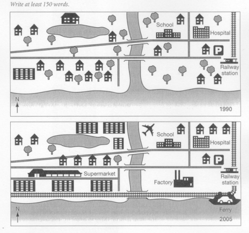
The map illustrates the changes that have occurred in Templeton, a seaside resort, over a 15-year period beginning in 1990 and ending in 2005.
The most noticeable change is the replacement of many green areas with several major infrastructure projects. (or A significant modification observed is the conversion of numerous green spaces into multiple substantial infrastructure undertakings.)
To begin, there were several major changes to transport in the town. An airport has been built beside the river on the outskirts of the town. In addition of this a ferry port was constructed on the far east coastline, with a new railway extension line passing by the ferry port, continuing along the coast and crossing over a new bridge so it connects to the west side of the town.
There have also been changes to the business sector in Templeton. A factory can be seen in the southeast of the town behind the new railway line and a supermarket has been built over the river in the west of the Templeton, running alongside a new road.
The residential landscape has also altered, particularly on the west side of town, where large apartment blocks now stand in the place of houses.
Word Count: 199