Our system will evaluate the answer based on this AI-generated description.
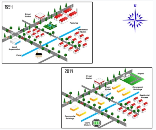
The image presents two isometric maps comparing urban layouts for the years 1954 and 2014. In the 1954 map: there are multiple residential houses arranged in rows, a petrol station located near the lower left, one local supermarket adjacent to the petrol station, a canal running horizontally near the lower side, and three blocks of factories behind the residential houses. In the 2014 map: the setup includes several residential houses, a petrol station retained in the same position, a larger supermarket labeled "Super Market," expanded commercial buildings spread across the middle of the setup, a new sports stadium named "Sports Stadium" toward the lower right, and an airport located at the upper right. The layouts also showed an increased road network in 2014. No specific numerical data or percentages about sizes, number of buildings, or population data are provided in the image.
Given the complexity of the image, the above description may not be entirely accurate.
Skyrocket your IELTS band score by 1-2 points in under a month with our premium plan!
Note: Both the topic and the answer were created by one of our users.
The following images give information on the alterations that took place in a town in the USA from 1954 to 2014.
Overall, it is clear from the illustrations that the town witnessed dramatic changes. The most important changes are that an airport and many commercial buildings were constructed.
To begin, one of the most striking transformations is the development of commercial buildings across the canal and alongside the roads. An airport was constructed after demolishing the factories in the northeast part of the map. Additionally, the park, which was in the vicinity of the factories, was replaced with a supermarket.
Next, the church was knocked down before setting up a sports stadium in the southwest area so as to allow people to watch some matches. A local supermarket was replaced with two commercial constructions on the western side of the map, next to the intersection of two roads. However, there are also some things that have remained unchanged, such as the trees, most of the residential houses, and the petrol station with the canal.
Word Count: 174